
Region: Cortina d’Ampezzo — Ampezzo Valley, Dolomites, Italy
Places To Stay: Stay central in Cortina d’Ampezzo for buses, shops and easy starts. If you prefer something quieter Corvara, Canazei and Selva di Val Gardena work well too. Looking for more Dolomites trails? Head to my ‘Dolomites Hiking Guides‘ page to see all regions and routes.
Below are a few ideas for day tours and transfers around Cortina d’Ampezzo, with GetYourGuide offering great discounts and easy booking + a huge amount of options in the Dolomites area, see more here.
For a wider choice of accommodation in the Dolomites, Booking.com has a huge variety to browse through.
Lago Di Sorapis Trail #215 is a up and down on the same track hike, the end point is a beautiful glacial lake, framed Hollywood style at the foot of Dito di Dio (“Finger of God”). As you get really close to the top, you walk through some very large rocks, and then suddenly you see the lake and the mountain behind it, it’s an unbelievable feeling, almost spiritual.
We walked this in May, and there was still a lot of snow around at the top, but this just added to the experience. But it meant we didn’t get to see the aqua blue lake as it was frozen over which it’s famed for, and why thousands hike this route every year, but at the same time we did get the lake side pretty much to ourselves.
Getting There: Directions, GPX and Map
- Start/Finish: SR48, 32043 Cortina d’Ampezzo BL, Italy (SR48 Falzarego road) car park/bus stop.
- Transport: Seasonal buses from Cortina travel along that road. Parking available but can fill up in peak season.
- Download the GPX file here.
- Follow this route on my Outdooractive profile.
Travel Data: I use eSIMs to stay connected — quick setup and no roaming faff. Sim Local has been solid in Italy/Europe with good prices and coverage.

Hike Profile
- Distance: ~8m / 13km.
- Duration: 6-6.5 hours (lots of sightseeing)
- Highest Point: 6312ft / 1923m
- Difficulty: Moderatly difficult (steep short climbs).
- Terrain: Loose terrain through the woods and cliff side edges with cable guides, but season depending as snow can be thick in Spring
- Best for: Views, WW1 history, relaxed alpine walking, first-time Dolomites visitors
Flying into Italy? Quick Skyscanner Checker
From Heathrow, we flew to Venice Marco Polo, and hired cars, Skyscanner found the cheapest flights, try the flight widget above.
Hike Description
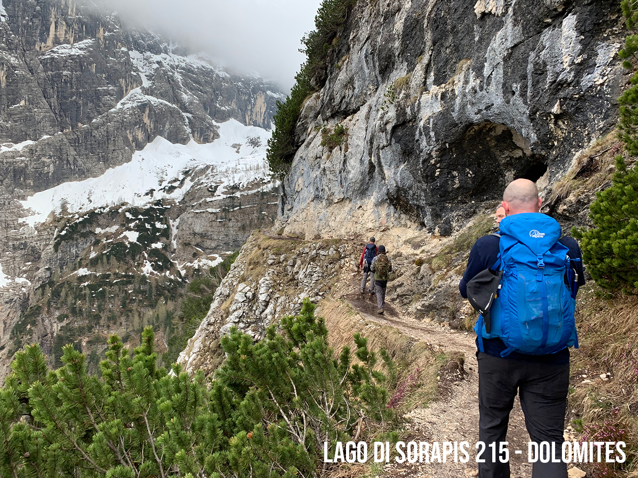
The hike to Lago Di Sorapis, isn’t difficult, it’s mostly well warned paths, and because this is a very popular path, the rocks underfoot in some areas have become very slippery, so be careful when stepping up. Otherwise, the path up is the same as the one down, but if you want a bit more exposure and are confident with your abilities you can come down on trail numbers 216 and 213.
If you are doing this route in the summer, you might be relieved to come down on these alternative paths, as the sheer number of people doing route 215 at the same time, can be a bit over whelming. The start point is on road ‘SR48‘ and is very close to B&B Hotel Passo Tre Croci Cortina on the same side of the road. At the start of the path there is a tourist information board, and the path number 215 will be displayed on tree’s and signs and is the same for all the trails in the Dolomites.


It’s a beautiful start to the walk, with the pine trees lining the path through the forest, and as you wind your way around you pass some WW2 bunkers, really interesting. Continuing your walk the trees open slightly on your left to reveal the mountain ranges surrounding this area, it is spectacular.


The forest continues for a while yet as you keep heading up, winding your way through and in some areas the paths become a little less solid, but still good enough to not have to worry, but once out of the forest you find yourself in a different environment, rocky cliff edges, incredible panoramic views everywhere and very steep rock faces on your right.


It’s just a case of making your way up now, and you know you’re close as you start to make your way through large boulders and you can see the peak of Dito di Dio in front of you, to make it even more dramatic for us, we had snow to get through, it was about a foot deep but there was a path through it.


And here is the magnificent ‘Lago Di Sorapis‘ in May 2023, snow covered and dramatic, exciting, and mystical, an amazing place to be anytime of the year!


Once you are ready to walk back, you take the exact same route, but this time you can face the mountains in the distance and take those in.
We all said we need to return to the Dolomites in summer, yes it will be busier but to experience the aqua blue lakes and the beautiful green and wildlife will be a new experience again.
Places to Stay in the Dolomites – My Picks
I’ve put together a few guides to make choosing a hotel in the Dolomites easier. If you’re after a romantic break, I’ve found some cosy hideaways. If it’s hiking that’s front and centre, I’ve rounded up the best hotels with trails right from the door. There are also ski-in ski-out favourites, family-friendly bases, and hotels with those wow-factor mountain views or even hot tubs to sink into after a long day.
- Most Romantic Hotels in the Dolomites ⇢
- Best Hotels for Hiking in the Dolomites ⇢
- Best Ski-In Ski-Out Hotels in the Dolomites ⇢
- Best Family Friendly Hotels in the Dolomites ⇢
- Best Hotels with Mountain Views in the Dolomites ⇢
- Best Hotels with Hot Tubs in the Dolomites ⇢
Places to Stay in Cortina
For a wider choice of accommodation in the Dolomites, Booking.com has a huge variety to browse through.
Recommended Stays

Right in the centre of the famous ski resort of Cortina d’Ampezzo, the 4-star Hotel De La Poste is set in an early 19th-century building. It features 2 restaurants and free WiFi throughout.

Parc Hotel Victoria is a great hotel to relax in Cortina, the staff are ready to help at all times and are very friendly. It is located very close to the promenade, shops and restaurants in Cortina, and simple access to the buses.

AllTrails: Trail Guides & Maps for Hiking, Camping, and Running | AllTrails ‘Plus’ 30% OFF – Read my ‘Full Review‘ for more details.
Practicalities
- Start early: An early start means quieter paths and better light.
- Footwear: Trail shoes are fine in dry weather; boots are better after rain as limestone paths can be slick.
- Cash: Rifugi often prefer cash for drinks, snacks, or toilets.
- Food & water: While you can pack a picnic, the nearby Rifugio Vandelli offers simple, authentic hot meals from late June to September, with stunning views of the surrounding peaks
- Weather: Storms can build quickly in the Dolomites. Pack a waterproof even on blue-sky mornings.
- Navigation: Very well signed, but a GPX is handy if mist rolls in.
- Crowds: Expect busy paths late morning to mid-afternoon in peak season.
- Best season: June to late September, depending on snow levels.
Cinque Torri Circular FAQs
How long is the Lago Di Sorapis walk?
Is Lago Di Sorapis suitable for beginners?
Can I use a cable car?
How difficult is the walk?
Is Lago Di Sorapis good for kids?
Are dogs allowed?
Is the route well marked?
Can I combine this with other walks?
Is it busy in summer?

Walk this route yourself in 3D!
The video is a 3D walkthrough of this route; it’ll give you a great idea of what to expect before you set foot on the mountain.
I’ve created 3D videos of my walks and shared them with the Outdooractive and Welsh Man Walking communities.
Lago Di Sorapis Circuit Trail – Hike the Italian Dolomites – Path 215 – 3D Video

Water-to-Go Named Best Water Bottle for Travel. Click www.watertogo.eu + 20% Discount Using – ‘WMW20’
Disclosure: I may earn a commission if you buy via the links on this page — at no extra cost to you.