


Region: Yr Wyddfa (Snowden), Eryri National Park, (Snowdonia) North Wales.
Places To Stay: Stay in Caernarfon for buses, shops, pubs & restaurants. If you prefer something quieter Llanberis, Conwy and Barmouth work well too. Looking for more trails in Wales? Head to my ‘Wales Hiking Guides‘ page to see all regions and routes.
Below are a few ideas for day tours and trips around Eryri (Snowdonia), with GetYourGuide offering great discounts and easy booking + a huge amount of options in the Noth Wales area, see more here.
For a wider choice of accommodation in Eryri (Snowdonia) National Park, Booking.com has a huge variety to browse through.
The Watkin Path is one of six routes up to the summit of Yr Wyddfa, and in my opinion it is the toughest, the steep slopes near the top particularly from the Rhyd Ddu Path are challenging, and not to be underestimated. The first part however is an easy gradual climb through the tree’s and then as you enter the clear, you will see the peak and also the Rhaeadrau Waterfalls which you will pass, and maybe as we did, have a little swim in!
The path is obvious most of the way to the top from the car park, and you will pass some really interesting landmarks, which I will show below.
Getting There: Directions, GPX and Map
- Start/Finish: Pont Bethania Car Park, Nant Gwynant.
- Transport: Buses run all around the area, and there are many park and rides, which I would highly recommend especially in the peak seasons.
- Download the GPX file here.
- Follow this route on my Outdooractive profile.
Travel Data: I use eSIMs to stay connected — quick setup and no roaming faff. Sim Local has been solid in Italy/Europe with good prices and coverage.

Hike Profile
- Distance: ~8m / 13km
- Duration: 7-8 hours
- Highest Point: 3524ft / 1074m
- Difficulty: Difficult
- Terrain: Difficult very steep short climbs, loose terrain, slippery in places, rock scrambling and weather can be very dangerous.
- Best for: Views, history, cold water swimming, first-time Yr Wyddfa visitors
Flying into England? Quick Skyscanner Checker
Hike Description
The start point is at ‘Pont Bethania Car Park, Nant Gwynant‘, there is limited car parking, and it does get busy, and from there you can set off left, past the public toilets, over the bridge that spans ‘Afon Glaslyn’, crossing the main road and starting your walk up through the woods.
The tourist info board in the car park is a great source of information, and gives some great advice and local information. When you cross the road, you will be greeted by a lovely bit of Welsh stone with ‘Llwybr Watkin Path’ marked into it, you are on your way!


Follow the ‘Cambrian Way’ path up through the beautiful woods that takes you over a couple of little bridges, and is filled with the sounds of nature. The path will end when you come to a set of gates, and you will head left up the path to continue your way up.
Just outside those gates is a nice view point and another information board, the trail turns into a stone path and as you turn the bend you will see Yr Wyddfa way in the distance, and the waterfalls in front of you, around to the right.


You can walk to the left of the waterfalls and follow the path up, but we noticed a path down to the waterfalls with a little bridge, so we crossed over walked up with the waterfalls on our left, and later on you re-join the same path anyway.
But we enjoyed the moment by the waterfalls, stripped off and had a dip and it was freezing cold, but so nice, then dried quickly in the sun and carried on walking up. This was such a treat and a beautiful section to this walk, and in hindsight we should have had a dip on the way down, but it was so tempting we couldn’t resist it.


Leaving the waterfalls, the path continues on a slight up slope as you make your way towards the peak, and on your left a famous rock will appear, called the Gladstone Rock. It is here where The Watkin Path was named after Sir Edward Watkin, he created this path as the first hiking trail in England in 1892.
At the official opening, Prime Minister William Gladstone stood on this rock to give a speech to more than 2,000 people. Since then, this stone is known only under the name Gladstone.


You are now on your way to starting on the steeper sections, and it only gets harder from here to the top.
The path up is very well maintained, lots of slabs to walk on and step up, as you walk to the top on the right side of the valley. We did this walk on a nice day, but I can imagine these steps can get very slippery on a bad day, and the weather can change so quickly up here so always be prepared for all weathers.


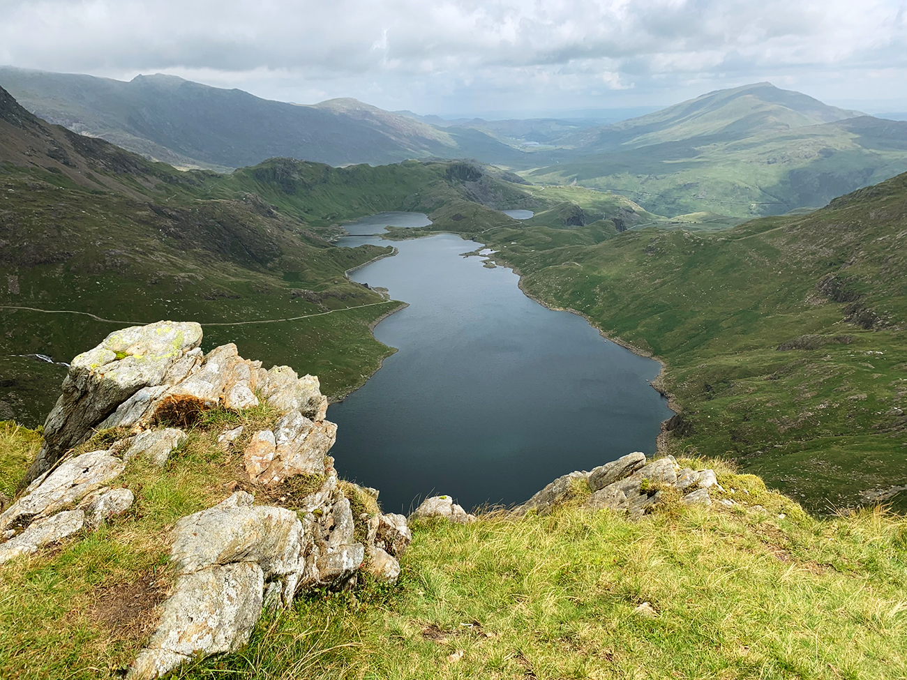
As you climb up, on your right is the Craig-Ddu peak at 550m, pretty small for the area, but you soon reach a new high point and this is called the ‘Y Lliwedd (West Peak)’, and on your right you will see a plateau appear, walk to the end and you will get a spectacular view down the valley, overlooking ‘Llyn Llydaw’ and the most popular paths coming to the peak another way which are the ‘Miners Track’ and the ‘Pyg Track’.


We had a little break here, and then went back to the path and carried on a little further, and it’s at this point we stopped to have a proper lunch and coffee break. The place where we stopped is called ‘Bwlch y Saethau’ and again you get spectacular views, but it’s also the last gentle bit before the brutal last climb to the peak, so it was a wise stop.


Once at the top, you can give yourself a huge pat on the back, as it’s a very decent climb, and takes some doing. The peak is where the train arrives and you have a lovely building to use with toilets and serves drinks and food.
It does get very busy, as there are a few different ways up and if you want a pic at the trig point you can expect quite long ques. I cross my fingers that you have a view to look at, we didn’t, only clouds, but it didn’t matter as we saw everything on the way up anyway.


Leaving the peak, you start by heading back the way you came up to the trig point, but rather than go down to the left, carry on straight and this will allow you to return along the South Ridge.
This isn’t an easy walk back down, it’s very craggy and at points you will not have a path but as you head forward, you can see the path in the distance. There are some really large rock formations to climb over and down, so be very careful, and then it’s a walk down to the little bridge you crossed over not far up from the waterfalls.


There are still 2 more peaks you will go over, the first is ‘Clawdd Coch’ standing at 931m, and then just before you leave the high points there is ‘Allt Maenderyn’ standing at 704m, so as you can see you are starting to drop quite quickly.
The views are superb as you head down, it’s a lot to take in, but you have plenty of time as it’s quite a long walk back.
Here are a couple of extra pics on the way down, making your way back to the car along the lower path that you came up on.


Places to Stay close to The Watkin path – My Picks
For a wider choice of accommodation in Eryri National Park, Booking.com has a huge variety to browse through.
Recommended Stays

Bryn Dinas Camping Pods at the foot of Mt Snowdon in Beddgelert offers a sun terrace and a garden. Guests can enjoy mountain views and relax in the outdoor fireplace and seating area.

Sygun Cottage in Caernarfon offers a two-bedroom, two-bathroom holiday home with a spacious garden and free WiFi. The property includes a fully equipped kitchen, cosy fireplace, and a seating area.

AllTrails: Trail Guides & Maps for Hiking, Camping, and Running | AllTrails ‘Plus’ 30% OFF – Read my ‘Full Review‘ for more details.
Practicalities
- Start early: Yr Wyddfa is popular for good reason. An early start means quieter paths and better light.
- Footwear: Trail shoes are fine in dry weather; boots are better after rain as paths can be slick.
- Food & water: Best pack before, it’s always sensible, but there is a cafe at the top with toilets also.
- Weather: Storms can build quickly in Snowdonia. Pack for everything even on blue-sky mornings.
- Train option: Using the train from Llanberis saves ascent — but book ahead.
- Navigation: Very well signed and trodden, but a GPX is handy if mist rolls in.
- Crowds: Expect busy paths late morning to mid-afternoon in peak season.
- Best season: May to late September.
Cinque Torri Circular FAQs
How long is the Watkin Path?
Is the Watkin Path suitable for beginners?
Can I use a train?
How difficult is the walk?
Is the watkin Path good for kids?
Are dogs allowed?
Is the route well marked?
Can I combine this with other walks?
Is it busy in summer?

Walk this route yourself in 3D!
The video is a 3D walkthrough of this route; it’ll give you a great idea of what to expect before you set foot on the mountain.
I’ve created 3D videos of my walks and shared them with the Outdooractive and Welsh Man Walking communities.
Yr Wyddfa (Snowdon) in Eryri National Park via Watkin Path – 3D Video

Water-to-Go Named Best Water Bottle for Travel. Click www.watertogo.eu + 20% Discount Using – ‘WMW20’