
Region: Monmouth, Redbrook and the Wye Valley, Monmouthshire
This longer Kymin circular walk from Monmouth combines a beautiful stretch beside the River Wye with Redbrook, the Wye Valley Walk, Offa’s Dyke Path and the viewpoint from the Kymin. At 7.2 miles, it is a much more complete route than simply driving to the Kymin car park and walking around the grounds.
The walk begins in Monmouth town centre, follows the River Wye towards Redbrook and then climbs steadily through the lanes and woods on Offa’s Dyke Path. After reaching the Kymin, the path descends on the opposite side and returns across Wye Bridge into Monmouth.
I first completed this route in the summer of 2022, which is when most of the photographs were taken, and walked it again on 4 October 2026 to check that the GPX and route were still accurate. It remains one of my favourite lower-level walks around Monmouth.
| Distance | 7.2 miles / 11.6 km |
|---|---|
| Total ascent | 991 ft / 302 m |
| Highest point | Approximately 837 ft / 255 m at the Kymin |
| Moving time | Approximately 4 hours |
| Total time | 4 hours 44 minutes including stops |
| Route type | Circular |
| Direction | Anticlockwise |
| Difficulty | Moderate – mostly straightforward, with a sustained climb from Redbrook |
| Start | Cattle Market Car Park, Monmouth |
| Parking | Paid town-centre car park |
| Navigation | GPX recommended at path junctions |
| Last route check | 4 October 2026 |
Important: the riverside part of this route is susceptible to flooding. Do not attempt the walk when the River Wye has flooded the path. The route also includes a short section beside the busy A466 and a road crossing into Redbrook.
Parking, map and GPX
- Start and finish: Cattle Market Car Park, Monmouth
- Google Maps: Cattle Market Car Park
- Parking: paid parking; check the tariff and maximum stay displayed when you arrive
- Outdooractive route: view and follow the route
- Komoot route: full Komoot route
- GPX: download the GPX file
- If you are unfamiliar with GPX navigation, read my plain-English guide to what a GPX file is and how walkers use one.
Monmouth has shops, cafés, pubs, toilets and other town-centre facilities close to the start and finish. There are no dependable facilities during the countryside section, so carry the food and water you need.
Kymin circular route overview
- Leave Cattle Market Car Park and walk through Monmouth towards Wye Bridge.
- Cross Wye Bridge and join the riverside path and Wye Valley Walk towards Redbrook.
- Leave the river, walk briefly beside the A466 and cross carefully into Redbrook.
- Join Offa’s Dyke Path and follow the sustained climb past Jamie’s Farm towards the Kymin.
- Explore the free Kymin grounds and enjoy the view over Monmouth and the surrounding hills.
- Continue on Offa’s Dyke Path, descend to Monmouth and cross Wye Bridge again.
- Return through the town centre to Cattle Market Car Park.
The Kymin circular walk from Monmouth
Monmouth to the River Wye
We started from Cattle Market Car Park in Monmouth town centre. It is a convenient base because you can finish the walk with coffee, food or a look around the shops, and there are plenty of facilities close to the car park.
From the car park, head through the town and towards Wye Bridge. Cross the bridge and pick up the route on the opposite bank, near the road leading towards the Monmouth School sports facilities.
This is where you meet the Wye Valley Walk. We initially used a parallel path closer to the river before rejoining the recognised route farther along. Follow the GPX because several paths run through this area.


The photographs were taken during our summer walk, when the riverbanks were green and the trees provided welcome shade. It felt surprisingly continental in places, with open grass, woodland and the river almost constantly beside us.
Following the River Wye towards Redbrook
Continue along the riverside path, passing small beaches and clearings. At one point the lower path rises back up the bank and rejoins the Wye Valley Walk. The GPX makes this transition easier to identify.


When we first walked here, we met a local man and his dog collecting other people’s litter from the path. He was friendly and happy to chat, and his request was simple: please take your rubbish home and help keep the riverbank as beautiful as you found it.
The route continues beneath an old iron bridge and through alternating woodland and open fields. The shade is very welcome on a warm day, but the riverside setting should not disguise the flood risk. If the river has covered the path, turn back and save the walk for another day.


There are attractive clearings where you can stop for food and watch the wildlife on the river. We entered the water during our hot 2022 walk, but river conditions and water quality can change quickly. Do not assume a calm-looking stretch is safe, and never enter during or after flooding.


Redbrook and the climb on Offa’s Dyke Path
At the end of the riverside field, continue through the woods until the route reaches the A466. Walk beside the road for a short distance and choose a clear, safe opportunity to cross into Redbrook. Traffic can be fast, so this is the section that requires the most care.
The woodland contained some interesting artwork on the trees during our earlier visit. These details may change over time, but the public route itself was still clear when I checked it again in October 2026.


After entering Redbrook, the route joins Offa’s Dyke Path and begins the main climb of the day. Follow the lane, pass beneath the bridge and turn onto the track climbing towards Jamie’s Farm.
The route passes the farm on a public right of way; it does not require entering the farm, and walkers should not assume that the site is open for casual visits. Continue on the signed path and respect the surrounding private land.


The climb from Redbrook is sustained and accounts for most of the route’s difficulty. It is not technically hard, but after the long riverside approach it requires a reasonable level of fitness. Keep following the Offa’s Dyke signs and use the GPX at junctions.
The Kymin viewpoint
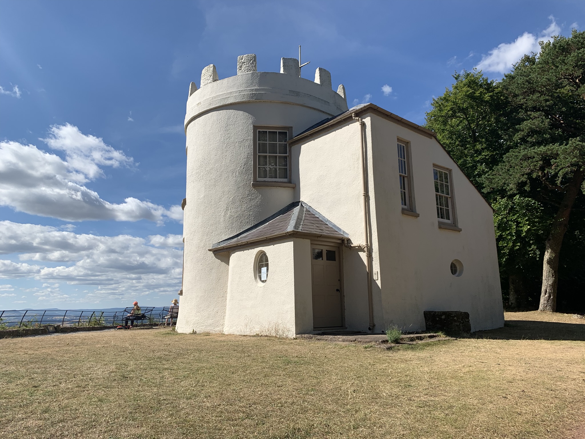
The Kymin is the focal point of the walk. The grounds are free to explore and provide wide views over Monmouth, the River Wye and towards the Sugar Loaf and Blorenge. The buildings were not open for entry during my latest visit, so treat the viewpoint and grounds as the dependable part of the experience.
It is a good place to stop for food and a rest before beginning the descent. Please take everything away with you and leave the grounds as you found them.


Descending to Monmouth
When you are ready to leave, continue on Offa’s Dyke Path rather than returning the way you climbed. The descending path begins beside the Kymin buildings and leads down through woodland, past attractive homes and gardens and back towards Monmouth.
On reaching the road, turn towards Wye Bridge and cross the river for the second time. You can return directly to the car park or walk through the centre of Monmouth. We chose the latter and finished with coffee and cake before heading home.


This is a varied and rewarding Monmouth walk. The River Wye provides a gentle first half, the climb from Redbrook adds a proper physical challenge, and the Kymin supplies the viewpoint before a straightforward descent back to town.
Practical information
- Flooding: do not attempt the route if the River Wye has flooded the riverside path.
- Road safety: take care beside and when crossing the A466 at Redbrook.
- Footwear: walking shoes or boots with reliable grip are sensible, particularly after rain.
- Navigation: the signed long-distance paths help, but the GPX is useful where local paths meet.
- Livestock: sheep may be visible behind farm fencing; keep dogs controlled.
- Facilities: use the cafés, shops and toilets in Monmouth; carry everything needed for the route itself.
- Kymin access: the grounds are free to walk around, but do not rely on the buildings being open.
- Suitability: suitable for reasonably fit beginners, families and dogs, but the distance and climb from Redbrook should not be underestimated.