


If you’ve downloaded Outdooractive and are wondering whether it’s worth upgrading to Pro or Pro+, you’re not alone. It’s a question I get asked a lot.
I’ve been using Outdooractive for years and it’s become one of the most important tools I use, not just for hiking but also for running this website. Every route you see on Welsh Man Walking has been created, planned, checked or shared using Outdooractive in some way. From mountain days in Wales, Italy, Norway, Switzerland and beyond to city walks around London and Tokyo, every guide links to a trail saved on my Outdooractive profile.
The free version is excellent and offers more than enough for many walkers. However, once you start hiking regularly, planning longer routes or venturing into areas with poor mobile signal, the benefits of upgrading become much easier to justify.
In this guide I’ll explain the differences between Outdooractive Free, Pro and Pro+, the features I use most often, and which subscription I believe offers the best value for hikers in 2026.
If you’re already convinced, and want to upgrade, you can use my discount code WELSHMANRI9I6 for money off your first subscription. It will entitle you to a 10 Euro discount at the checkout for both the Pro and Pro+ versions. Visit my Outdooractive Discount Code page, for more information.
Discount code to copy: WELSHMANRI9I6
Quick Recommendation
If you’re looking for the short answer:
| Type of Walker | Recommendation |
|---|---|
| Casual walker | Free |
| Regular UK walker | Pro |
| Mountain walker | Pro+ |
| Long-distance trail walker | Pro+ |
| European hiking trips | Pro+ |
| Route creators and bloggers | Pro |
For most people reading this, Outdooractive Pro is the best option. It gives you offline maps, official mapping, route planning tools and navigation features that genuinely improve your experience on the trail.
However, if you regularly hike in mountain environments, travel abroad or simply want access to every available mapping layer and planning tool, Outdooractive Pro+ is worth considering.
Why I Use Outdooractive for Every Route on Welsh Man Walking
Before we look at the individual features, I think it’s important to explain why I use Outdooractive so heavily.
When I first started Welsh Man Walking, I needed a reliable way to plan routes, record hikes and share them with other people. I experimented with several apps, but Outdooractive quickly became the platform I kept coming back to.
Today, every route on Welsh Man Walking links back to Outdooractive. I use it to:
- Plan new hiking routes.
- Check distances and elevation gain.
- Create GPX files.
- Download maps before heading into the hills.
- Navigate routes while walking.
- Share routes with readers.
- Embed routes directly into my website.
Many of the routes I publish are in places where mobile signal is unreliable. Anyone who regularly walks in the Brecon Beacons, Eryri, the Lake District or Scotland will know that phone signal can disappear very quickly once you leave the car park.
Being able to download routes and maps before I leave home is one of the biggest reasons I continue to pay for a subscription.
It’s one thing reading a list of features on a website. It’s another relying on those features when you’re standing on a mountain in thick cloud trying to make sure you’re heading in the right direction.
That’s probably the main reason I upgraded to Outdooractive Pro and Pro+, and I use this feature a lot!
Why First-Hand Experience Matters
One of the reasons I wanted to write this guide is because many reviews online are simply feature comparisons written by people who may never have used the app beyond a quick test. This review is different.
The routes, reviews and hiking guides on Welsh Man Walking are based on real walks and real experiences. The same applies to Outdooractive.
I’ve used it while creating route guides across Wales, England, Scotland, Italy and beyond. I’ve used it to plan long hiking days, build GPX files, navigate unfamiliar trails and manage hundreds of published routes on this website.
That’s important because the value of Outdooractive isn’t found in a marketing bullet point. It’s found in how those features actually work when you’re outdoors.
So rather than simply listing what’s included in Pro and Pro+, I’m going to explain which features I genuinely use, which ones I think are worth paying for and which subscription I would choose depending on the type of hiking you do.
Outdooractive Free vs Pro vs Pro+ At a Glance
If you’re short on time and just want the quick answer, here’s a simple breakdown of the three Outdooractive memberships.
| Feature | Free | Pro | Pro+ |
|---|---|---|---|
| Route Planning | ✓ | ✓ | ✓ |
| Route Recording | ✓ | ✓ | ✓ |
| GPX Import & Export | ✓ | ✓ | ✓ |
| Offline Maps | ✗ | ✓ | ✓ |
| Offline Routes | ✗ | ✓ | ✓ |
| Ordnance Survey Maps (UK) | ✗ | ✓ | ✓ |
| Satellite Maps | ✗ | ✓ | ✓ |
| BuddyBeacon Live Tracking | ✗ | ✓ | ✓ |
| Route Collections | Limited | ✓ | ✓ |
| HARVEY Maps | ✗ | ✗ | ✓ |
| Alpine Club Maps | ✗ | ✗ | ✓ |
| 3D Terrain Maps | ✗ | ✗ | ✓ |
| Snow Depth Layer | ✗ | ✗ | ✓ |
| Advanced Weather Layers | ✗ | ✗ | ✓ |
At first glance the jump from Free to Pro looks much bigger than the jump from Pro to Pro+. That’s because Pro unlocks the features most walkers use every day, including offline maps, official mapping and route planning tools.
Pro+ is more about giving serious hikers, mountain walkers and international travellers access to additional mapping layers and advanced planning tools.
For many people, Pro will be all they ever need. However, if you’re regularly hiking in the mountains, planning trips to the Alps or spending a lot of time creating and researching routes, Pro+ starts to make much more sense.
Let’s look at the features in more detail.
What Do You Get With Outdooractive Pro?
For most walkers, Outdooractive Pro is where the app really starts to come into its own.
The free version is a great way to discover routes and get a feel for the platform, but once you start planning regular hikes, creating your own routes or venturing into areas with poor mobile signal, you’ll quickly begin to appreciate the additional features that come with Pro.
These are the Pro features I personally use most often.
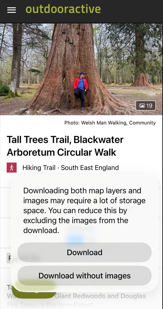
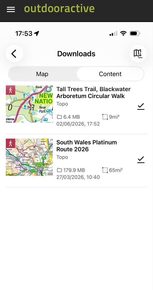
1. Offline Maps and Routes
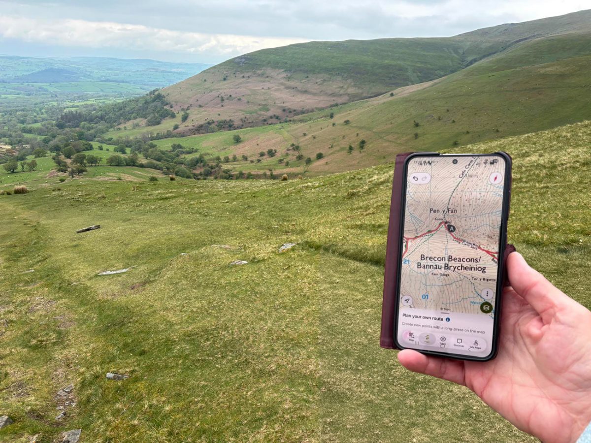
If I had to choose a single reason to upgrade to Pro, this would be it. Before every hike I download both the route and the surrounding map area to my phone. It takes a couple of minutes at home but can save a lot of stress later on.
Many of the walks featured on Welsh Man Walking are in places where mobile signal can be unreliable. The Brecon Beacons, Eryri (Snowdonia), parts of the Lake District and many areas of Scotland all have sections where signal can disappear completely.
Having offline maps means I can still see my location, follow the route and navigate safely even when I have no signal at all.
It’s a feature you might not think you’ll need until the day you do, and believe me, I have been through this scenario, and it can be quite scary.
2. Ordnance Survey Maps
As UK walkers we’re lucky to have access to some of the best mapping in the world.
One of the biggest benefits of Outdooractive Pro is access to official Ordnance Survey mapping, including Explorer and Landranger maps.
When I’m planning routes for Welsh Man Walking, I regularly switch between map layers to check rights of way, identify terrain features and make sure routes are practical and enjoyable to follow.
The level of detail available on OS maps is fantastic and gives much more confidence when navigating unfamiliar areas.
For many UK hikers, this feature alone justifies the cost of the subscription.
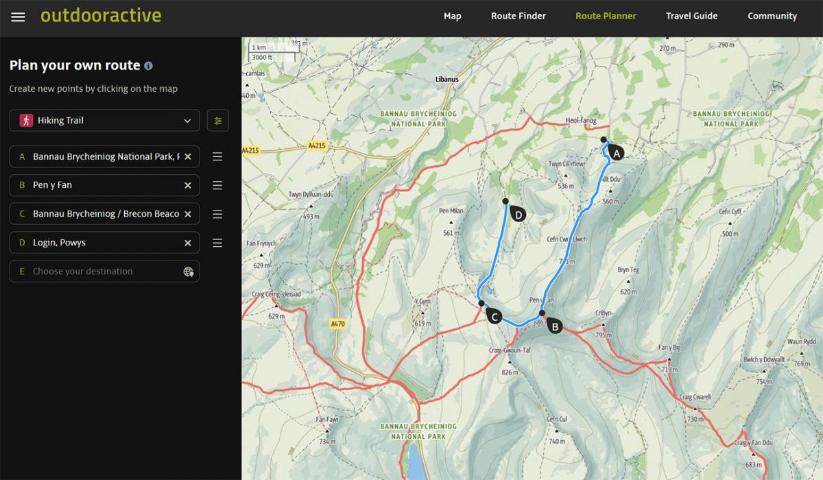
3. Route Planning and Creation
This is another feature I use almost every week.
Whether I’m creating a brand-new route for the website or simply tweaking an existing walk, Outdooractive’s route planning tools make the process incredibly straightforward.
I can quickly plot routes, check distances, view elevation profiles and estimate hiking times before I ever set foot on the trail.
When you’re building hundreds of routes like I have for Welsh Man Walking, having reliable route planning tools becomes essential.
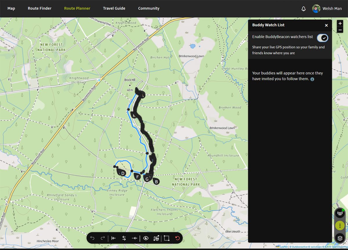
4. BuddyBeacon Live Tracking
If you regularly hike alone, BuddyBeacon is a feature that’s easy to overlook but incredibly useful.
It allows friends and family to track your progress while you’re out on the trail.
I’ve always believed that mountain safety starts long before you leave the car park. Letting someone know where you’re going and when you expect to return is one of the simplest safety measures you can take.
BuddyBeacon adds an extra layer of reassurance, particularly on longer or more remote walks.
5. Satellite Maps
Satellite imagery can be surprisingly useful when researching new routes.
I often use it when looking for parking locations, checking trail conditions, identifying woodland sections or getting a better understanding of the terrain before visiting somewhere for the first time.
It’s not a feature I use every day, but when I need it, it’s incredibly helpful.
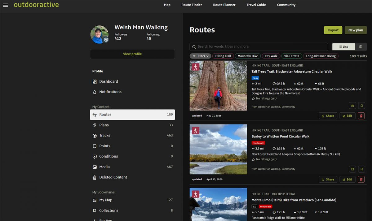
6. Route Collections
As Welsh Man Walking has grown, I’ve found myself organising routes into collections more and more.
For example, I can group together walks from a particular region, long-distance trails or routes linked to a specific trip.
It’s a simple feature but one that helps keep everything organised, especially if you enjoy planning multiple adventures throughout the year.
Is Outdooractive Pro Worth It?
For most people, yes.
If you’re only heading out for the occasional local walk, the free version may be enough.
However, if you regularly hike, follow GPX routes, plan your own adventures or walk in areas where mobile signal isn’t guaranteed, I think Outdooractive Pro offers excellent value.
The combination of offline maps, Ordnance Survey mapping and route planning tools transforms Outdooractive from a route discovery app into a genuine navigation and planning tool.
For many hikers, Outdooractive Pro will be all they ever need.
What Additional Features Do You Get With Outdooractive Pro+?
If Outdooractive Pro is aimed at regular walkers and hikers, Outdooractive Pro+ is designed for people who want access to the most detailed mapping and planning tools available within the platform.
The jump from Free to Pro is the biggest upgrade for most users. The jump from Pro to Pro+ is more specialised.
Whether Pro+ is worth the extra money really depends on the type of walking you do.
For me, the biggest appeal of Pro+ is access to additional map layers and planning tools that become increasingly useful when you’re venturing into mountainous terrain or hiking abroad.
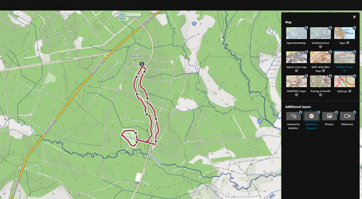
1. Harvey Maps
If you’re a regular mountain walker in the UK, HARVEY Maps are one of the standout features of Pro+.
Many experienced hikers swear by HARVEY Maps because they’re specifically designed for outdoor navigation. The maps are clear, easy to read and remove much of the clutter that can sometimes appear on traditional maps.
I’ve used HARVEY maps on several mountain routes and particularly like how easy they are to read at a glance when you’re trying to make quick navigation decisions.
If most of your hiking takes place in the hills and mountains of the UK, this feature alone may make Pro+ worth considering.
2. Alpine Club and International Maps
One of the reasons I enjoy using Outdooractive is that it works just as well abroad as it does in the UK.
Whether you’re hiking in the Dolomites, the Alps, Norway or further afield, having access to detailed local mapping can make route planning significantly easier.
As someone who regularly creates hiking content outside the UK, having these additional mapping options available is a major advantage.
If your adventures rarely leave Britain, you may not use these maps very often. However, if you’re planning hiking holidays across Europe, they become much more valuable.
3. 3D Terrain Maps
This is one of those features that’s difficult to appreciate until you start using it.
Viewing a route in three dimensions gives you a much better understanding of what the terrain actually looks like.
You can quickly see where the steep climbs are, identify ridges, understand the shape of a valley and get a much better feel for the route before setting off.
When I’m researching new routes, particularly in mountainous areas, I often find myself switching to the 3D view to help visualise the terrain.
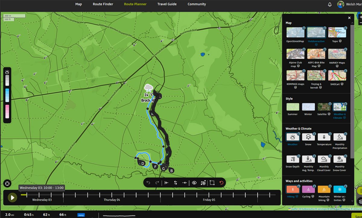
4. Advanced Weather Layers
Weather can have a huge impact on a day’s hiking.
Pro+ provides additional weather information and weather layers that can help you make better decisions before heading out.
While I always recommend checking dedicated weather forecasts before any walk, having weather information integrated directly into your route planning can be very useful.
This becomes even more important when planning mountain walks where conditions can change rapidly.
5. Snow Depth Information
For winter walkers, this can be a genuinely useful feature.
Snow conditions can dramatically change the difficulty of a route and affect both safety and equipment requirements.
Being able to view snow depth information during the planning stage gives you additional information that can help you decide whether a route is suitable for the conditions.
If you regularly walk in winter mountain environments, this is one of the more valuable Pro+ features.
6. Better Planning for Big Adventures
The more I use Outdooractive, the more I realise that Pro+ is really aimed at people planning bigger adventures.
If you’re heading out for a five-mile countryside walk on a Sunday morning, Pro is probably more than enough.
However, if you’re planning a week in the Alps, researching multi-day trails, tackling long-distance routes or spending a lot of time exploring mountainous terrain, the additional mapping and planning tools begin to make much more sense.
It’s less about one individual feature and more about having every available tool at your fingertips when planning complex adventures.
Is Outdooractive Pro+ Worth It?
The answer depends entirely on how you hike.
If most of your walking takes place in the UK and you’re mainly following established routes, Outdooractive Pro is likely to provide everything you need.
However, if you regularly:
- Walk in mountainous terrain
- Travel abroad for hiking trips
- Plan long-distance routes
- Enjoy detailed route research
- Use HARVEY Maps
- Want access to every available mapping layer
then Outdooractive Pro+ becomes a much more attractive option.
For serious hikers, the additional cost is relatively small when compared with the overall cost of boots, clothing, travel, accommodation and other outdoor gear.
If you’re already investing heavily in your hiking adventures, having access to the best available mapping and planning tools can be money well spent.
👉 Don’t forget you can use my discount code WELSHMANRI9I6 to get 10 EURO off your upgrade.
Which Outdooractive Subscription Should You Choose?
After using Outdooractive for years and building hundreds of routes through Welsh Man Walking, my advice is actually quite simple. Don’t buy more than you need.
Outdooractive offers three levels of membership for a reason, and the best option depends entirely on how often you hike and where your adventures take you.
Choose the Free Version If…
The free version is surprisingly capable and may be all you ever need if you:
- Enjoy occasional local walks.
- Primarily follow well-marked trails.
- Don’t need offline maps.
- Rarely create your own routes.
- Are simply looking for route inspiration.
If you’re new to hiking or just want to explore what Outdooractive has to offer, there’s absolutely nothing wrong with starting here.
In fact, I’d recommend trying the free version first before deciding whether you need the additional features, this is what I did.
Choose Outdooractive Pro If…
For most readers of Welsh Man Walking, this is the option I’d recommend.
Outdooractive Pro is ideal if you:
- Walk regularly throughout the year.
- Use GPX files.
- Plan your own routes.
- Want offline maps and navigation.
- Walk in areas with unreliable mobile signal.
- Use Ordnance Survey maps.
- Enjoy discovering new routes.
This is the subscription I believe offers the best balance between cost and features.
The offline mapping alone can justify the annual fee if it saves you from getting lost or having to rely on patchy mobile signal in the hills.
For the majority of UK walkers, Outdooractive Pro hits the sweet spot.
Choose Outdooractive Pro+ If…
Pro+ is aimed at people who are serious about hiking and route planning.
You should consider Pro+ if you:
- Frequently walk in mountainous terrain.
- Travel abroad for hiking holidays.
- Enjoy researching and planning routes in detail.
- Want access to HARVEY Maps.
- Use advanced weather and snow information.
- Tackle long-distance trails.
- Simply want every mapping and planning tool available.
If you’re planning trips to places like the Alps, Dolomites or Norway, the additional mapping options become far more valuable.
Likewise, if you’re the sort of person who enjoys spending an evening researching routes before a trip, you’ll probably appreciate the extra planning tools that come with Pro+.
What Would I Choose Today?
If I was starting from scratch and mainly hiking around the UK, I’d choose Outdooractive Pro without hesitation.
It includes the features I rely on most often:
- Offline maps.
- Offline routes.
- Ordnance Survey mapping.
- Route planning tools.
- GPX support.
- Navigation.
For most hikers, that’s where the best value lies.
However, because I regularly create hiking content, research routes and travel abroad, I can also see the appeal of Pro+.
The additional map layers, HARVEY Maps and advanced planning tools are genuinely useful when you’re planning bigger adventures.
My Honest Recommendation
If you’re unsure, start with Pro. I think most people will quickly get value from offline maps, OS mapping and route planning tools. You can always upgrade to Pro+ later if you find yourself wanting more detailed mapping or planning more ambitious hiking trips.
For many walkers, Pro will be all they ever need.
For mountain enthusiasts, long-distance hikers and people who spend as much time planning adventures as they do walking them, Pro+ becomes a much easier purchase to justify.
👉 And don’t forget you can use my discount code WELSHMANRI9I6 to get 10 EURO off your upgrade. It’s money off, so why wouldn’t you.
Outdooractive vs Komoot
One of the most common questions hikers ask is whether they should choose Outdooractive or Komoot.
The truth is that both are excellent platforms, but they have slightly different strengths.
Komoot is incredibly easy to use and is particularly popular with walkers, runners and cyclists who want a simple way to discover and navigate routes.
Outdooractive, however, feels like the more complete platform for serious hikers and route planners.
Where Outdooractive really stands out is the depth of mapping available, the route planning tools and the amount of hiking-specific information available when researching new adventures.
As someone who creates and shares routes regularly through Welsh Man Walking, I find Outdooractive gives me more flexibility and more detailed planning tools than Komoot.
If you’re looking for a straightforward navigation app, Komoot is excellent.
If you’re passionate about hiking, route planning and exploring both the UK and Europe, I believe Outdooractive has the edge.
Outdooractive vs OS Maps
As a UK walker, I’ve spent plenty of time using Ordnance Survey maps and there’s no denying how good they are.
If all of your walking takes place in the UK, OS Maps remains one of the best mapping tools available.
However, Outdooractive offers something different.
Not only do you get access to Ordnance Survey mapping through a Pro subscription, but you also gain route planning tools, route discovery, GPX management, community routes and international mapping options.
For me, Outdooractive combines the strengths of OS Maps with additional tools that make planning and sharing routes much easier.
If your walking never leaves the UK, OS Maps is a fantastic option.
If you enjoy travelling, discovering new routes and having everything in one place, Outdooractive becomes a very attractive alternative.
I’ll be publishing a dedicated Outdooractive vs OS Maps comparison soon, as it’s a topic that deserves a much deeper look.
Frequently Asked Questions
Is Outdooractive worth paying for?
Can I use Outdooractive offline?
Does Outdooractive include Ordnance Survey maps?
What additional maps are included with Pro+?
Is Outdooractive better than Komoot?
Is Outdooractive better than OS Maps?
Can I export GPX files from Outdooractive?
Does Outdooractive work outside the UK?
Is Outdooractive suitable for beginners?
Which Outdooractive subscription do you recommend?
Final Verdict
After years of using Outdooractive both on the trail and behind the scenes at Welsh Man Walking, it’s become one of the few hiking tools I genuinely wouldn’t want to be without.
The free version is a great starting point and offers enough functionality for many casual walkers.
However, if you hike regularly, create your own routes or venture into areas where mobile signal can’t be relied upon, upgrading to Pro is an easy recommendation.
The combination of offline maps, Ordnance Survey mapping, route planning tools and navigation features provides excellent value for money and will be more than enough for most hikers.
Pro+ takes things a step further by adding premium mapping layers and advanced planning tools that are particularly useful for mountain walkers, long-distance hikers and those who enjoy exploring further afield.
If you’re unsure which option to choose, I’d start with Pro.
It’s the subscription I believe offers the best balance of features, practicality and value for the majority of walkers.
Whatever level you choose, Outdooractive remains one of the best hiking apps available today and a platform I continue to use for every route I create and share through Welsh Man Walking.